Friends of Shenandoah Mountain
  • Home
  • Proposal
    • Shenandoah Mountain National Scenic Area >
      • Little River Wilderness
      • Bald Ridge Wilderness Addition
      • Skidmore Fork Wilderness
      • Lynn Hollow Wilderness
    • Collaboration with GWNF Stakeholders
  • Learn
    • Wilderness FAQs
    • National Scenic Area FAQs
    • Landowner FAQs
    • Dispelling Myths
    • History of Shenandoah Mountain >
      • History of Staunton Dam
      • History of High Knob Fire Tower
      • History of Sexton Shelter
      • Camp May Flather
      • Flood of 1949
    • References on Shenandoah Mountain Ecology
  • Threats/Benefits
    • Threats >
      • Atlantic Coast Pipeline
    • Economic Benefits
    • Water Quality
    • Recreation
    • Trails
    • Short Hikes
    • Birding and Wildlife Trails
  • Supporters
    • Endorsers
    • Local Governments
    • Quotes
    • Videos
  • News
  • Endorse

Proposed Pipeline Route over Shenandoah Mountain - New Map

10/24/2014

0 Comments

 
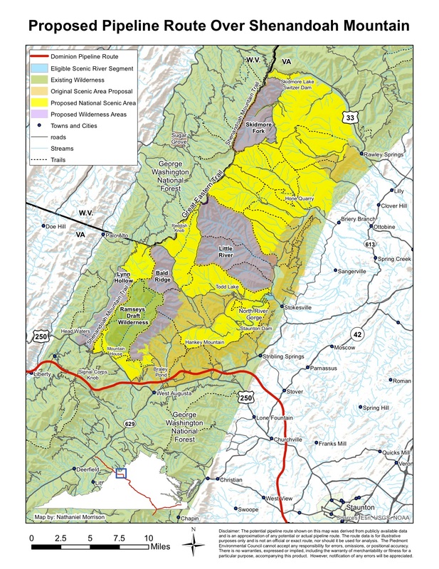
A new map developed by JMU GIS major Nathaniel Morrison shows the proposed Dominion pipeline route over Shenandoah Mountain.  If approved, the pipeline would pass through the proposed Shenandoah Mountain National Scenic Area near Braley Pond and the Ruffed Grouse Management Area on Hankey Mountain.   Many thanks to Nate for developing this map.
Picture
0 Comments

Your comment will be posted after it is approved.


Leave a Reply.

    RSS Feed

Home     |     Proposal     |     Learn     |     Threats/Benefits     |     Supporters     |     News     |     Endorse


Contact Friends of Shenandoah Mountain
info@friendsofshenandoahmountain.org
5653 Beards Ford Rd.
Mt. Crawford, VA 22841
(540) 234-6273