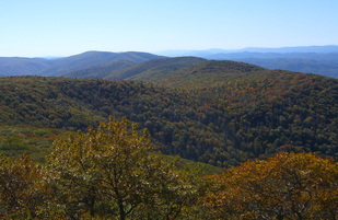
 Shenandoah Mountain as seen from Reddish Knob
 The GW North River District Ranger has asked for special help with cleaning up Reddish Knob. They have just cut the vegetation for the view at the summit, but that has exposed all the trash beneath. Before the new leaves come out, and before the Memorial Day visitors, can we haul some of that away?
Yes! And we can enjoy the view while we're at it! Come for an hour after work this Thursday, May 22nd. Rain or shine. Wind your way up the paved road to the very top, 4,397 feet tall. There is no other spot higher to the northeast until the Adirondacks in NY. You'll be overlooking the largest roadless area east of the Mississippi (the Little River Watershed, which runs to the Shenandoah River), and a biodiversity hotspot. Just before sunset, no less!
Because of the recent cut, wear heavy boots and pants, and heavy gloves for trash. Bags will be provided, and trucks to haul them down the mountain. Dress for 10 degrees cooler than the Valley. Sponsored by Headwaters Master Naturalists, teaming with Friends of Shenandoah Mountain, with appeals to the Sierra Club, and Mountain Biking Club. The more people, the merrier! (And the more trash we can haul out in a hurry!)
Driving Directions: From Dayton, travel 6 miles west on Rt. 257. At stop sign in Ottobine, turn left to continue on Rt. 257. Travel 2.8 miles, and turn right in Briery Branch to continue on Rt. 257. Continue on this road all the way up Shenandoah Mountain through the GWNF. The road is narrow and curvy, so drive carefully and use turnouts for approaching vehicles when needed. After 9.5 miles, at the gap and intersection of 3 roads, turn left to continue on the paved road. Drive for two miles, then bear left at fork. Drive .5 miles to the wide paved parking lot at the summit. See you there!
More info: Sandy Greene, Project Committee, Headwaters Master Naturalists: 540-487-1224 [email protected]
 RSS Feed